带空间权重的分级统计地图
一个变量的地图,上面叠加邻接网络——这是所有空间统计赖以成立的结构。
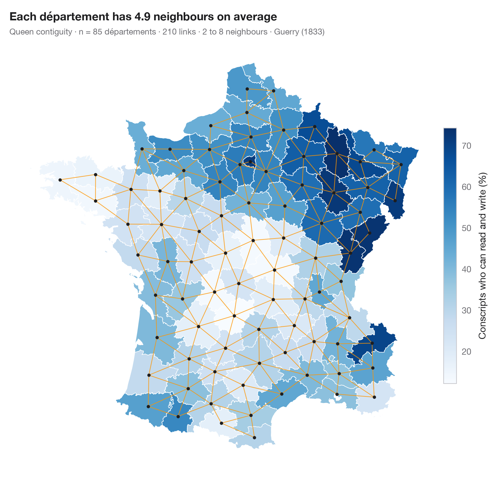
所有空间统计都从决定"谁是谁的邻居"开始。这张图在进行任何检验之前展示这一决定:一个变量的分级统计地图,并用线连接每一对相邻地区的中心。这里,共享边界或角点的地区互为邻居(后式邻接);权重矩阵的每一行随后被标准化,因此一个地区的"空间滞后"就是其邻居的平均值。其他选择——车式邻接、k 近邻、距离带——会产生不同的网络并可能改变结果,所以值得先看一看这个网络。
数据来自安德烈-米歇尔·盖里的《法国道德统计论》(1833 年):约 1830 年的 85 个省,由 Center for Spatial Data Science 整理,并用 libpysal 加载(examples.load_example("Guerry"),首次下载后缓存)。变量为能读写的应征士兵所占百分比。权重来自 libpysal.weights.Queen,地图用 GeoPandas 绘制。
代码及图中文字均为英文。
import geopandas as gpd
import matplotlib.pyplot as plt
import numpy as np
from libpysal import examples, weights

# Data: 85 French départements, c. 1830 (Guerry, 1833)
g = gpd.read_file(examples.load_example("Guerry").get_path("guerry.shp"))
y = g["Litercy"]                      # % of conscripts who can read and write

# Queen contiguity: neighbours share a border or a corner
w = weights.Queen.from_dataframe(g, use_index=False)
cards = np.array(list(w.cardinalities.values()))
xy = np.column_stack([g.centroid.x, g.centroid.y])

fig, ax = plt.subplots(figsize=(8, 7.4))
g.plot(column=y, cmap="Blues", edgecolor="white", linewidth=0.6, ax=ax, legend=True,
       legend_kwds=dict(label="Conscripts who can read and write (%)", shrink=0.6, pad=0.01))
for i, nbrs in w.neighbors.items():
    for j in nbrs:
        if i < j:                      # draw each link once
            ax.plot(*xy[[i, j]].T, color="#FF9500", lw=0.8, alpha=0.8)
ax.scatter(*xy.T, s=10, color="#1D1D1F", zorder=3)
ax.set_axis_off()
ax.set_title(f"Each département has {w.mean_neighbors:.1f} neighbours on average", pad=26)
ax.text(0, 1.02, f"Queen contiguity · n = {w.n} départements · {int(w.s0 / 2)} links · "
        f"{cards.min()} to {cards.max()} neighbours · Guerry (1833)",
        transform=ax.transAxes, fontsize=9.5, color="#6E6E73")
plt.show()
图表使用了可选的 PyStatlas 样式:添加 plt.style.use("pystatlas.mplstyle") 即可完全还原其外观。
数据来源
- Guerry's moral statistics of France, c. 1830 (85 départements). Guerry, A.-M. (1833). Essai sur la statistique morale de la France. Crochard. Data as compiled in Friendly, M. (2007). A.-M. Guerry's moral statistics of France: Challenges for multivariable spatial analysis. Statistical Science, 22(3), 368–399. https://doi.org/10.1214/07-STS241
Prepared by the Center for Spatial Data Science (University of Chicago) from the R package Guerry (Friendly and Dray), provided “as is”. Fetched once and cached by libpysal (examples.load_example("Guerry")). Variables come from Guerry's tables as translated by Whitt and Reinking (2002).
这些示例用于说明统计方法。图表标题描述的是该图在这些特定数据中呈现的内容——这些数据往往样本较小、年代较早或并不完整——而不是作者对实质问题的立场。关于解释、背景和数据质量,请以此处引用的原始来源为准。
如何引用
PyStatlas 由 Thierry Warin 创建并维护。如果它对你的工作有所帮助,敬请引用。
Warin, T. (2026). Choropleth with spatial weights. In PyStatlas: A Python Gallery of Statistical Graphics for the Social Sciences. https://warint.github.io/pystatlas/spatial-data/spatial-weights/
@misc{warin2026statlas,
  author       = {Warin, Thierry},
  title        = {PyStatlas: A Python Gallery of Statistical Graphics for the Social Sciences},
  year         = {2026},
  howpublished = {\url{https://warint.github.io/pystatlas/}},
  note         = {Source code: https://github.com/warint/pystatlas}
}